Regions of Georgia
30b - differentiate the five geographic regions of Georgia including the Blue Ridge Mountains, Ridge and Valley, Appalachian Plateau, Piedmont and Coastal Plain
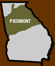
Piedmont
Piedmont is one of 5 regions in Georgia. The Georgia Piedmont is located between the Blue Ridge Mountains and the Upper Coastal Plain.
Saprolite, or Red clay, which is commonly found in Georgia, covers the rocks in the Piedmont region. The Piedmont contains the Fernbank Forests, which have different species of oaks, hickories, poplars, and pine trees. 10,000 years ago, Native American people inhabited this region of Georgia. Poultry and hog production are important agricultural activities in the region. When European settlers came to this region, cotton plantations and dairy farming marked its dominance. Also, when they arrived in this section of Georgia, they cut down a majority of the mature forests here and planted either tobacco or cotton crops, resulting in lots of erosion. The Piedmont was originally known as the " Cotton Belt", before the outbreak of the Civil War. As a result of the erosion caused by the cotton and tobacco plants , the original forests, made of oak and hickory, have only a few strands remaining. The first Gold Rush in the country was found in Dahlonega, which is also located in this region. The Piedmont is part of a much larger region called the Southern Piedmont. This region (The southern Piedmont) is approximately 1,400 km long and 100-300 km wide. That's big. Also, 1/2 of Georgia's population lives here, and this region is best known for Georgia's famous peaches. Atlanta, the capital and largest city in Georgia is also in Piedmont. It is the most industrial region due to its large population.
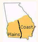
Coastal Plains
The Coastal Plains are one of 5 Geological Provinces of the State of Georgia. The Coastal Plains of Georgia are located in the Southern most part of Georgia, and they cover nearly 3/5 of Georgia. It is also the youngest of them all. The beginning of the Coastal Plains is marked by the "Fall Line". It goes all the way from Augusta, through Macon all the way to Columbus, and goes to the Modern Georgia Coast in the East, and the Florida State Line, in the South. The Coastal Plains are divided into two sub regions: The Inner Coastal Plain, and the Outer Coastal Plain. The Outer Coastal region is best known for its Vidalia Onions. The harder Igneous and Metamorphic rocks found here under the sediments, are usually called "The Basement". These rocks are just like the ones that are found in the Piedmont Region of Georgia. Also, there are many sedimentary layers. During the later part of the Triassic Period, when the super continent Pangaea split apart, the Coastal Plains of Georgia were formed. The oldest strata of sedimentary on the surface dates back to the Late Cretaceous Age.
The Coastal Plains are one of 5 Geological Provinces of the State of Georgia. The Coastal Plains of Georgia are located in the Southern most part of Georgia, and they cover nearly 3/5 of Georgia. It is also the youngest of them all. The beginning of the Coastal Plains is marked by the "Fall Line". It goes all the way from Augusta, through Macon all the way to Columbus, and goes to the Modern Georgia Coast in the East, and the Florida State Line, in the South. The Coastal Plains are divided into two sub regions: The Inner Coastal Plain, and the Outer Coastal Plain. The Outer Coastal region is best known for its Vidalia Onions. The harder Igneous and Metamorphic rocks found here under the sediments, are usually called "The Basement". These rocks are just like the ones that are found in the Piedmont Region of Georgia. Also, there are many sedimentary layers. During the later part of the Triassic Period, when the super continent Pangaea split apart, the Coastal Plains of Georgia were formed. The oldest strata of sedimentary on the surface dates back to the Late Cretaceous Age.
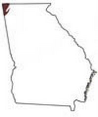
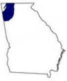
The Appalachian Plateau
The Appalachian Plateau is the smallest of the five physiographic regions of Georgia. The Plateau includes only Dade and part of Walker County in Extreme North Georgia. It is comprised of narrow valleys and wooded, rocky ridges. An example is Lookout Mountain. Also, last but not least, the Appalachian Plateau is Georgia's ONLY source of coal deposits, which is a fossil fuel. It is the least-visited site in Georgia. It is sometimes called the Cumberland Plateau. This plateau forms the Western boundary of the vast Appalachian Mountains. Located It is located in the North East corner of Georgia and contains many known tourist sites such as Sand, Lookout, and Pigeon Mountains.
The Appalachian Plateau is the smallest of the five physiographic regions of Georgia. The Plateau includes only Dade and part of Walker County in Extreme North Georgia. It is comprised of narrow valleys and wooded, rocky ridges. An example is Lookout Mountain. Also, last but not least, the Appalachian Plateau is Georgia's ONLY source of coal deposits, which is a fossil fuel. It is the least-visited site in Georgia. It is sometimes called the Cumberland Plateau. This plateau forms the Western boundary of the vast Appalachian Mountains. Located It is located in the North East corner of Georgia and contains many known tourist sites such as Sand, Lookout, and Pigeon Mountains.
Ridge and Valley
The Valley and Ridge region of Georgia has several mountain ridges and valleys created between them. The most important industries are the mining, farming, and textile/carpet manufacturing. Dalton, a city in Whitfield County, Georgia, is also in the Valley and Ridge Region, and is known as the "carpet capital of the world". This region lies between the Blue Ridge Mountains and the Appalachian Plateau. The Valley and Ridge Region also marks the beginning of the Appalachian Trail.
The Valley and Ridge region of Georgia has several mountain ridges and valleys created between them. The most important industries are the mining, farming, and textile/carpet manufacturing. Dalton, a city in Whitfield County, Georgia, is also in the Valley and Ridge Region, and is known as the "carpet capital of the world". This region lies between the Blue Ridge Mountains and the Appalachian Plateau. The Valley and Ridge Region also marks the beginning of the Appalachian Trail.
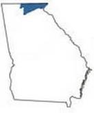
Blue Ridge
Brasstown bald (4784 ft above sea level) is the tallest mountain/highest peak in Georgia. It is located in the Blue Ridge Region of Georgia. The Blue Ridge has the highest amount of rainfall in Georgia. This region is known for its rugged beauty.. It is 100 miles wide. The ground is a mixture of sandy loam ( blend of clay, sand, and or organic matter) and clay. One of Georgia's 7 natural wonders, Tallulah Gorge is located here.
Brasstown bald (4784 ft above sea level) is the tallest mountain/highest peak in Georgia. It is located in the Blue Ridge Region of Georgia. The Blue Ridge has the highest amount of rainfall in Georgia. This region is known for its rugged beauty.. It is 100 miles wide. The ground is a mixture of sandy loam ( blend of clay, sand, and or organic matter) and clay. One of Georgia's 7 natural wonders, Tallulah Gorge is located here.
